Thank you for subscribing!
We'll send you updates on our latest news and events.

Sign up to receive updates on our latest news and events. Your email will never be shared or sold and you can opt out at any time.
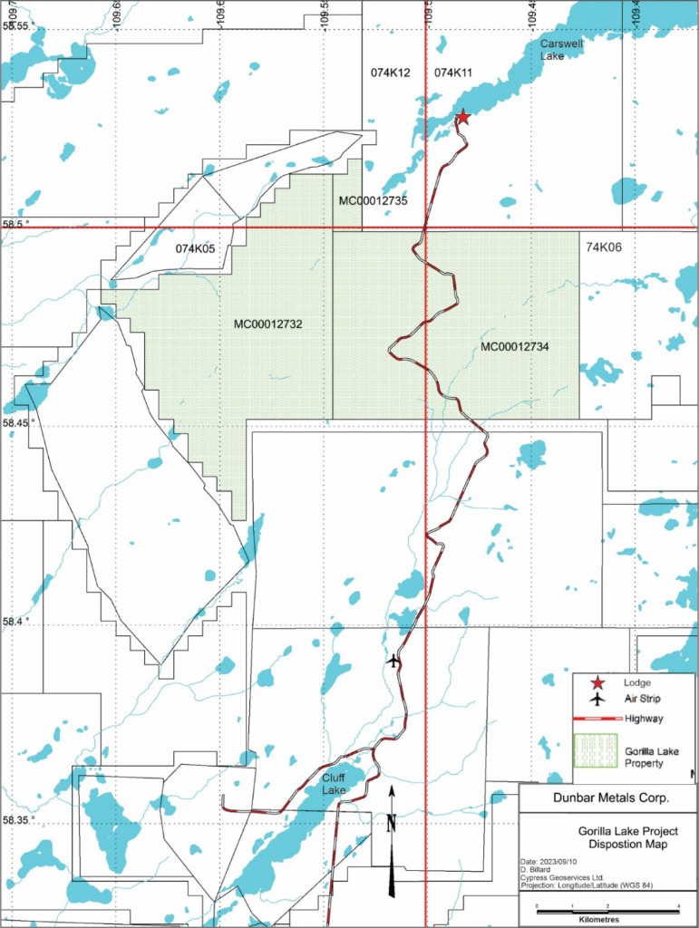
No thanksThe Gorilla Lake Property comprises 6,949.90 hectares in Saskatchewan's Northern Mining District, within the Carswell meteorite impact structure of the Athabasca Basin. The property is situated near the historic Cluff Lake Mine, which produced over 62 million pounds of U₃O₈ from 1979 to 2002.
Exploration is focused on identifying basin-hosted and unconformity-related uranium mineralization at the intersection of structural features and electromagnetic conductors.
Accessible via Highway 955 from La Loche, providing reliable all-season road access to the region.
Extensive surface vehicle trails throughout the property support efficient on-site access and exploration logistics.
The Cluff Lake airstrip and outfitter camps are located nearby, providing logistical support for exploration activities.
Source: Orano Canada News Release dated 2023-May-11
The property lies within the Carswell meteorite impact structure, creating a complex geological environment prospective for uranium mineralization. The geological setting supports both basement-hosted and unconformity-related deposit types, similar to the historic Cluff Lake deposits within the same structure.
Exploration targets the intersection of structural features and electromagnetic conductors — recognized indicators of uranium mineralization in this basin setting. Historic work concentrated on the western portion of the claim group, where anomalous uranium mineralization was intersected, leaving the bulk of the property significantly underexplored.
The Carswell Anomaly, wherein Gorilla Lake lies, has been the subject of exploration activity since the early 1950s.
Historic exploration concentrated on the western portion of the claim group, where anomalous uranium mineralization was intersected. The bulk of the property remains significantly underexplored.
A 2024 Company Heli-TEM survey identified several potential structural trends worthy of follow-up across the property.
As disclosed in the Company's June 10, 2026 news release, Gorilla Lake is advancing through a multiphase permitting and exploration sequence.
An upcoming airborne Time-Domain Electromagnetic (EM) survey, followed by ground truthing, is planned to follow up structural trends identified by the 2024 Heli-TEM survey.
The Company is permitting up to 7,000 metres of diamond drilling to follow up on the airborne survey and subsequent ground truthing.
Consultation with local First Nations and interested stakeholders in the Gorilla Lake area is underway as an integral part of the permitting process.
The Company will provide further updates as the permitting process advances and as exploration plans are refined. Read the June 10, 2026 release
Qualified Person: Tim Henneberry, P.Geo., is the designated Qualified Person as defined by National Instrument 43-101 – Standards of Disclosure for Mineral Projects. He is responsible for, and has reviewed and approved, the scientific and technical information contained on this page.