Thank you for subscribing!
We'll send you updates on our latest news and events.

Sign up to receive updates on our latest news and events. Your email will never be shared or sold and you can opt out at any time.
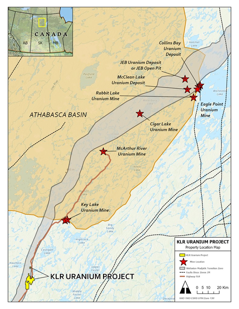
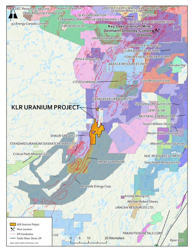
No thanksThe KLR Uranium Project covers approximately 5,521 hectares along the Key Lake Road, ~90 km south of Cameco's Key Lake Mine and mill, where over 209 million pounds of uranium were produced between 1983 and 2002.
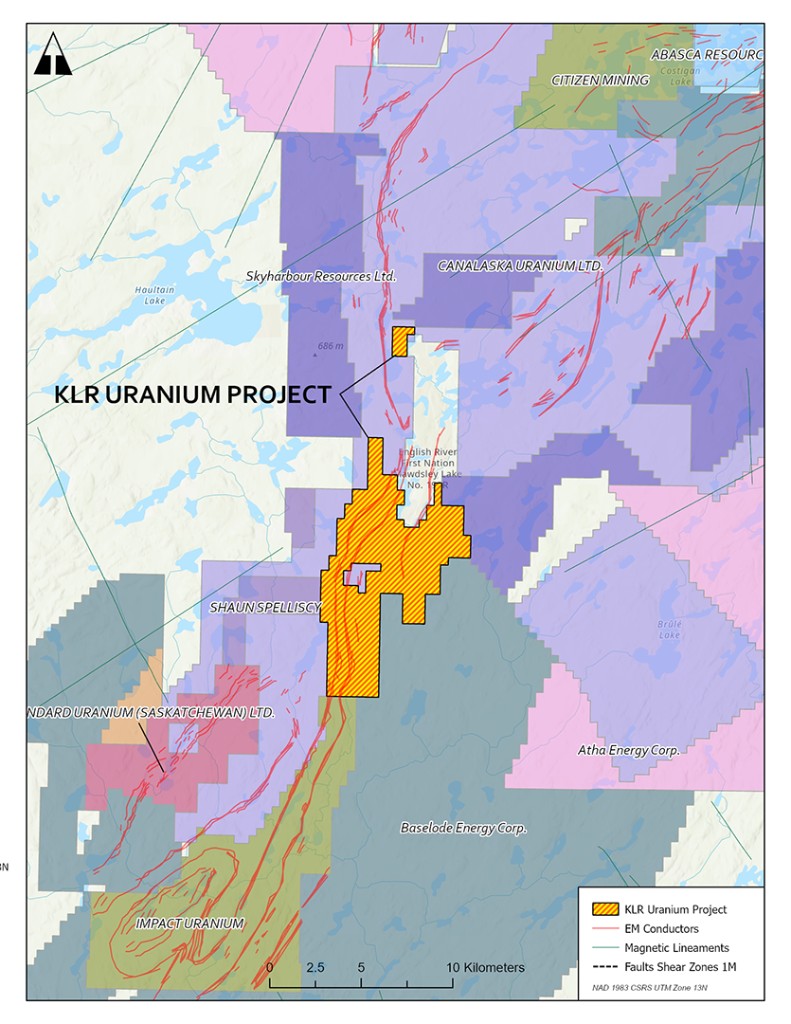
The property lies almost entirely within the Wollaston Mudjatik Transition Zone (WMTZ). Access is via provincial Highway 914, which bisects the property.
Provincial Highway 914 bisects the property, providing direct, all-season road access for exploration logistics.
Located approximately 90 km south of Cameco's Key Lake Mine and mill complex.
Proximity to established roads and regional mining infrastructure supports efficient exploration operations.
The KLR Project lies almost entirely within the Wollaston Mudjatik Transition Zone (WMTZ), the structural corridor that controls uranium mineralization at the Key Lake, Cigar Lake, and McArthur River uranium deposits.
The DD Zone is characterized by a north-south-trending fault consistent with the WMTZ. Historic prospecting and multiple drilling campaigns at the DD Zone have consistently identified highly anomalous uranium mineralization. Uranium enrichment increasing with depth has been interpreted in the context of a higher-grade feeder anomaly beneath near-surface radioactive halos.
Historical and 2023 exploration defined two key target zones — the DD Zone and the Highway Zone — with anomalous to high-grade uranium mineralization.
North-south fault consistent with the WMTZ. Uranium enrichment increasing with depth.
First identified by Forum Uranium. Six shallow holes drilled in 2023 intersected anomalous uranium enrichment increasing with depth.
Along Highway 914. Near-surface high-grade interval from 2015 work.
Ground geophysics and man-portable drilling in 2015 identified a near-surface interval of high-grade uranium mineralization.
Sources: Fall 2007 & Winter 2008 Drilling Report, Key Lake Road Project (Tan & Wheatley, 2008); Technical Report on the Key Lake Road Property (Harrington, 2016); 2023 KLR Drill Program Summary. Historical results have not been verified by the Company and are not treated as current.
As disclosed in the Company's June 10, 2026 news release, Key Lake Road is advancing IP and drill permitting focused on the DD Zone.
The Company is permitting up to 6.2 km of line cutting for an induced polarization (IP) survey. The IP survey is expected to assist in defining and sharpening drill targets for the upcoming program.
Permitting includes up to 30 drill holes targeting the DD Zone, which lies on a north-south-trending fault consistent with the Wollaston-Mudjatik Transition Zone.
Consultation with local First Nations and interested stakeholders in the Key Lake Road area is underway as an integral part of the permitting process.
The Company will provide further updates as the permitting process advances and as exploration plans are refined. Read the June 10, 2026 release
Qualified Person: Tim Henneberry, P.Geo., is the designated Qualified Person as defined by National Instrument 43-101 – Standards of Disclosure for Mineral Projects. He is responsible for, and has reviewed and approved, the scientific and technical information contained on this page.